Volcano and Wildfire Monitoring System
Version 2: 2020-04-28
Terms and Conditions
Terms and Conditions (Excluding an image of meteorological satellite "Himawari")
Your use of The Volcano and Wildfire Monitoring System (hereinafter referred to as the "System") shall be in compliance with the "Terms of Use of Research Data - Space Technology Directorate I" (http://earth.jaxa.jp/policy/en.html). Please read carefully and make sure you accept this article before using the System.
Terms and Conditions for use of an image of meteorological satellite "Himawari"
Images of the weather satellite "Himawari" in the System (hereinafter referred to as the "Himawari images") are provided by the P-Tree System (https://www.eorc.jaxa.jp/ptree). In cases of using "Himawari images", your use shall be in compliance with the Terms of Use for the P-Tree System (https://www.eorc.jaxa.jp/ptree/terms.html).
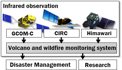
Overview of this System
Purpose
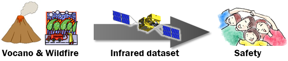
It is possible to monitor volcanic activities and forest fires widely and regularly by using satellite-observed infrared data. JAXA is currently researching such utilization of satellite-observed infrared data in cooperation with external agencies.
This System that provides satellite-observed infrared data to disaster prevention agencies is to contribute to prevention and mitigation of disasters in the future.
Expected Outcomes
This System provides satellite-observed infrared data to disaster prevention agencies, and aims at the following contributions:
- Volcano
-
Volcanic activities are monitored by various methods including a seismometer, GNSS observation and a ground camera.
However, there are some areas where the observation is limited. For example, there are very limited methods of monitoring from the ground in some islands. Therefore, the frequency of observation is limited. To cover such areas, by adding satellite-observed infrared data, JAXA aims at monitoring regularly variations of volcanic activities and intensifying of geothermal activities, and knowing where is affected due to large-scale volcanos. These data are useful for disaster mitigation and understanding of ocean volcanic activities, optimization of aircraft observations.
It is also expected that the satellite makes is possible to observe volcanic activities at the night and from right above.
For more detailed information about field observations of volcano, please refer to the websites of Japan Meteorological Agency and Japan Coast Guard.
- Wildfire
-
Most of forest fire in Japan are extinguished a few hours later, but in some cases they may spread to wide areas and continue for a few days or a few weeks.
Forest fires also spread to mountain areas where it is difficult to reach for extinguishment.
Therefore, the satellite observation is expected to know the spreading situation not only from a wide area and directly above, but also when the helicopter is impossible to be operated, such as at night or in bad weather.
Contact
For inquiries about this system, please contact us:
| contact details | Volcano and Wildfire Monitoring System Secretariat |
|---|---|
| address |
Satellite Applications & Operations Center (SAOC)
Space Technology Directorate I Japan Aerospace Exploration Agency (JAXA) 2-1-1 Sengen, Tsukuba, Ibaraki 305-8505 Japan |
 |